
As you leave Browning traveling West, the Blackfeet Reservation has a Buffalo Preserve within a mile or two of town. After seeing so many stuffed buffalo heads it was reassuring to see a healthy herd of the beasts on the range.

The Plains change dramatically as you enter foothills of the Rocky Mountains, their peaks rising in front of you.

The eagle eye perch of an old homestead kind of reminds us of what life used to be like in this wild country.

Glacial rivers, so clear and clean, they reflect their surroundings.

We camp at Camp Apgar, the west entrance to the park. The Going To The Sun Road Jim drove many years ago with his smallish motor home, is no longer accessible to Motor Homes. It takes you up over the Continental Divide and into Calgary, Canada if you choose to visit that part of the park. This is the beautiful and rustic MacDonald Lodge that sits next to MacDonald Lake. We set up camp, had lunch, and visited the lodge.
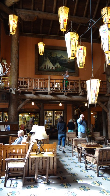
I believe it was built in 1911, all of it from local materials.

Each corner is held up by three giant cedar logs. The park has a trail where one can see some of these 500-year-old cedars.

Lodge patrons enjoyed the pleasant heat from the giant fireplace.

The Lodge has a totem but the plains tribes, the Native Americans that once lived and danced here, did not build totems.

Directly behind the lodge is the boat ramp on Lake MacDonald. Blue, blue clean, clear water reflects the peaks.

We bought tickets at $16.32 cents at the boat ramp. If it weren't a National Park, that price would be double. Such a bargain. You can order your tickets and reserve ahead of time, as well. We moved away leaving a road-like water con trail on the still surface of the lake. It made interesting abstracts on the water.

A close-up of our wake.

Cloud reflections on water ripples.

Rivers erode in a V shape. The U shape tells you a glacier once sat here. There are only two glaciers left in the park.

The boat carries us West toward the old town of Apgar. Two horrible fires hit the park. The worst was in 2003 when the "new" fire wisdom was to let the fire burn out. It consumed 43,000 acres and nearly took the town of Apgar.

At one time, all the burned trees would have been cut down. Now, scientists know the trees provide insect homes, draw birds and provide ground shade. Recovery is better and natural.

Its kind of fun to concentrate on the ever-changing surface of reflective water, helped by an overcast sky.

On the opposite side of the burn, high up on the peak, a crevice is eroding as water cascades down this slope during spring melt. The peak is also home to Dahl sheep and grizzleys.

We head back to the dock.

The light changes.

The glacier cradle darkens.

The burn regenerates. Not all trees die in a burn. A few remain and help the recovery and some trees fall on their own.

We return to the dock after a very pleasant hour on the lake the natives named, "Best Place For Dancing." The guide couldn't say the Indian name, just the meaning.

I DID see wildlife. This little ground squirrel popped up on our way back to the parking lot.
No comments:
Post a Comment